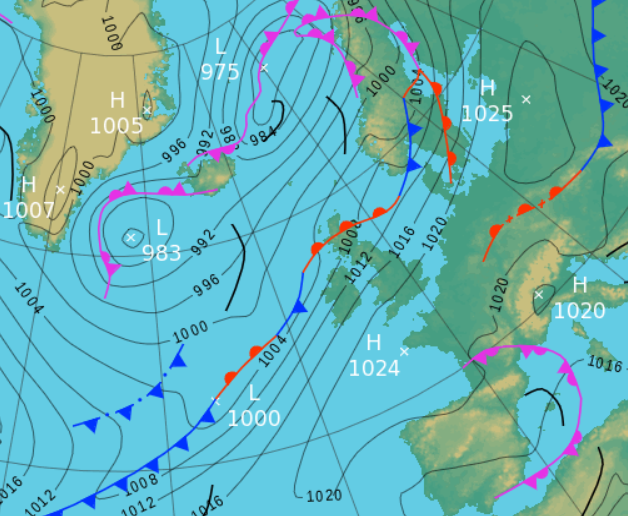
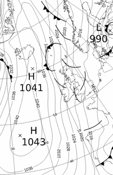
High pressure NW France giving a brisk SW'ly flow then migrating east and introducing a very mild southerly flow.
Both marginally wetter and colder than average - 'Storm Callum' brought two very wet days 12-13th and the month finished with several severe frosts
Like September, October was another fairly quiet month, but it still managed to provide a few days of notable weather!
'Storm Callum' on the 12-13th became a notable rainfall event that saw roads under water and impassable, but fortunately the flood waters stopped at the doorstep and did not venture further. Had it not been for Callum, which accounted for 70.1% of the month's rainfall, it would have been a dry month.
The days became generally dry after Callum until the final few days of the month saw a plunge of Arctic air bring several cold, but fairly sunny days. This saw two quite severe frosts and the lowest October temperatures yet recorded at this site.
Despite the third wettest 48hr period in my records, with an inch of rain falling on consecutive days and my coldest October temperatures, it was an uneventful month with there being not a single 'day of ...'. However, the number of frosts (7 air frosts and 12 ground frosts) was the most yet recorded in October.
MSLP of 1017.7 Mb was +6.8 Mb above the local average for October with pressure generally high throughout the month apart from Callum and then for the last two days.
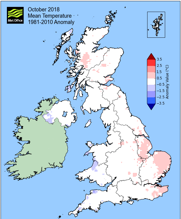
Overall a mean minimum of 4.55°c and a mean maximum of 12.85°c saw the temperature 0.4°c below the 1981-2010 average. It was the coldest since 2012 and of the ten now recorded, two have been colder and seven warmer. The highest maximum temperature recorded was 22.4°c (10th), the lowest minimum -5.3°c (30th).
Rainfall of 129.6 mm (Crosby Ravensworth School 143.0 mm - Castlehowe Scar 186.8 mm - Reagill 123.2 mm) was 113.3% of average for 2007-17 and made it the wettest October since 2014. Of the twelve now recorded, eight have been drier and three have been wetter.
At the Met' Office site at Newton Rigg, rainfall of 106.8 mm (99.9%) was the wettest since 2014 and in a series back to 1900 (data missing in one year), October has been drier in 69 years and wetter in 48 years.
A mean temperature of 9.04°c is the coldest since 2012 and in a series back to 1951, October has been warmer on 39 occasions, colder 27 times and with 1 year having the same mean temperature.
Locally, rainfall percentages were very close to average. They tended to teeter just onto the low side of average and at the majority of sites it was simply down to the rainfall of the 4th and 12-13th that got the total to somewhere approaching average. Curiously during the Storm Callum event, Brothers Water recorded a slightly greater total to that of Seathwaite.
Figures from the Environment Agency�s rainfall sites were, (figure in brackets being the monthly average for 1961-90) �Data kindly provided by the Hydrometry and Telemetry team of the Environment Agency (Penrith)�:
Kirkby Thore ** mm (65.8 mm)
Haresceugh Castle (Kirkoswald) 91.89 mm (101.0 mm)
Brothers Water 280.44 mm (276 mm) and
Orton (Shallowford) 148.0 mm (161.9 mm [average for 1967-2017])
380.0 mm at Seathwaite Farm (Borrowdale - 389 mm [average for 1981-2010]).
** not yet available
1st - 10th The general theme through the period was one of high pressure (HP) sat just to the south of the UK, occasionally ridging in over the UK, but which was also, occasionally, squeezed further south by frontal systems associated to low pressure (LP) systems passing over the top of the HP - all in all, with no pattern becoming dominant it became a mixed bag that included a couple of frosts and ended with a balmy summers-like day.
On the 1st the HP held just enough short lived influence to clear the skies for awhile overnight to give an air frost, but then the day itself became cloudy as a frontal system approached over the top of the HP. That was repeated on the 7th which saw another air frost, but in between the weather was slightly cooler than average with the best of any sun reserved for the 2nd and afternoon of the 6th. The 4th was the wettest day of the period which saw HP quickly giving way to a cold front approaching from the NW. A drab day followed with further rain overnight into the 5th to give 14.3 mm.
Quieter and cooler 6-8th with the HP out in the Atlantic holding a greater influence. That HP would slowly migrate east into Europe 8-10th bringing about a notable and dramatic change to the weather. As the HP moved east, LP took its place in the Atlantic thus creating a squeeze on the pressure gradient and introducing a brisk SW'ly flow. Then as the HP moved further east and left the UK at its western edge, the winds backed southerly and drew up a very mild airflow.
The 10th was a remarkable day - not a cloud to be seen and the temperature just went up and up, reaching the crazy heights of 22.4°c (72.3°f) - not the warmest October day recorded here, but certainly the latest autumn day in my records to attain 20°c.
High pressure NW France giving a brisk SW'ly flow then migrating east and introducing a very mild southerly flow.
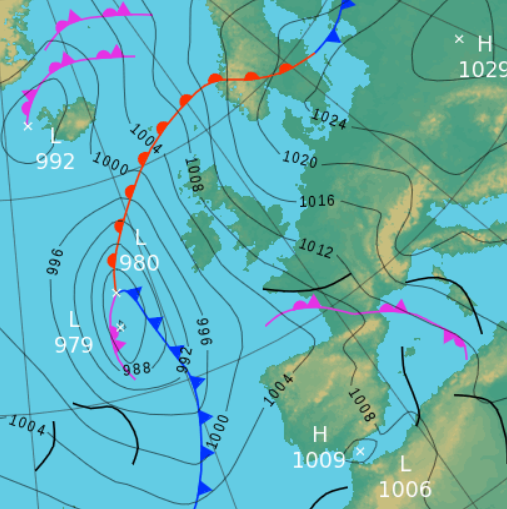
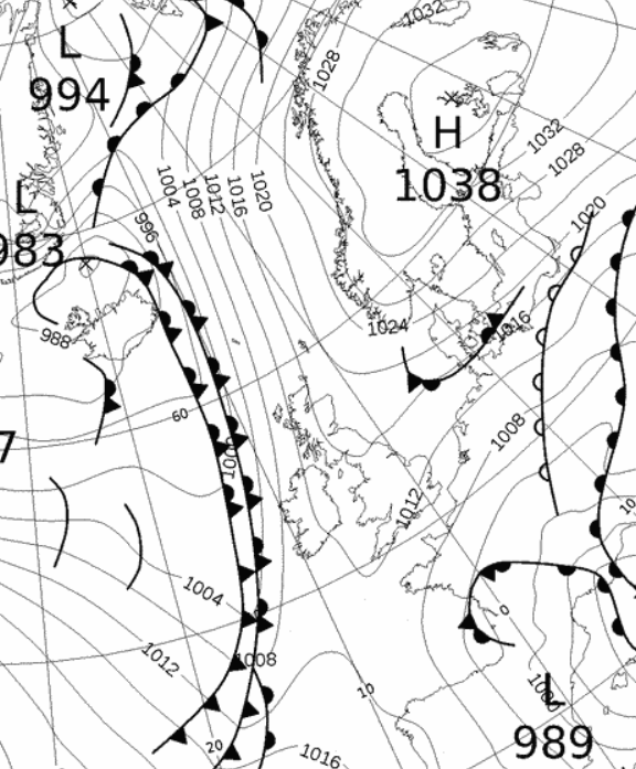
11th - 13th A very unsettled period with 'Storm Callum' bringing a prolonged spell of wet weather, that would become the third(**) wettest 48hr period in my records - fortunately flooding was restricted to the roads, with some becoming impassable, but whilst the waters lapped at the doors of a few houses, it did not enter.
The 11th saw LP out to the west of Eire trailing fronts over the UK and which in itself contributed 9.7 mm to the total, but Callum was racing towards the UK, shunting the other LP out of its way and which saw the rain arrive just before lunch on the 12th - it then did not stop raining until late in the evening on the 13th. In that time it deposited a total of 90.9 mm (55.8 mm 12th and 35.1mm 13th). It is also the fifth occasion in my records to have had an inch or more of rain on consecutive days.
Whilst we were fortunate to avoid the worst of the wind (reserved for the coastal fringes) with the strongest gusts just short of 50 mph, it was terribly mild. Even with the rain, the 12th reached 16.7°c and which was then beaten by 18.4°c on the 13th - in some respects it was 'Desmondesque', with the constant feed of mild southerly air and the fronts becoming semi-static over the UK, but fortunately only a very mini version.
** The top two wettest 48hr periods in my records belong to 'Storm Desmond' (4-5th Dec' 2015), but which was preceded by a wet day on the 3rd - so making the 3rd/4th the second wettest, with the 4-5th the wettest.
'Storm Callum' - passing to the west of Eire, bringing a feed of mild air and constant rain. Even when Callum had moved north of the UK the frontal system remained over the western portion of the UK.
14th - 25th HP would slowly start to exert itself over the UK and the weather became more settled, although at first with the occasional incursion of fronts from the Atlantic.
The 14th saw the remnants of the fronts associated to Callum clearing the UK and behind these HP ridged in. The afternoon was then one of sunny spells under clearing skies and which was followed by the 15th starting with a slight air frost before a day of sunny spells. However, this was ahead of an area of LP approaching from off the Atlantic which gave a fairly drab day on the 16th.
The fronts connected to that LP were relatively weak and would clear the UK during the 17th with HP in the Atlantic once again ridging in as those fronts cleared east - whilst often cloudy, it did now become the driest period of the month.
Temperatures were at or just below the seasonal norm' and by the 22nd the pressure had risen to an October high for this site, 1038.9 MB. From the 21st we then also started to enjoy a little more in the way of sunshine as well.
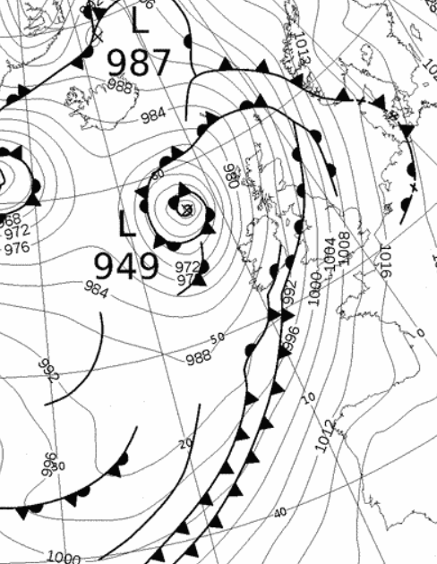
26th - 31st It was a cold end to the month we several severe frosts with Arctic air sweeping down over the UK. The HP that had been over the UK upto this point now elongated south-north in the mid-Atlantic and allowed the Arctic to flood down on its eastern flank.
The HP had begun to elongate during the 25th and by the 26th a cold front was sweeping down from the north and introducing that cold Arctic air. As well as it becoming cold by night, day-time maximums took a tumble well below 10°c for the first time this autumn.
The High pressure in the Atlantic that initially allowed a flood of Arctic air to sweep down across the UK, then the high pressure having ridged back across the UK to bring several severe frosts.
The day-time temperatures fell as low as 6.2°c (43.2°f) on the 27th and then settled down into a range of 7-9°c, but initially the winds were too strong to allow the night-time minima to drop below freezing.
The HP would then ridge back over the UK and whilst we enjoyed sunny spells during the day, the clearer skies allowed the temperature to fall away quickly after dark. A low of -4.7°c on the 29th was an October record for this site, but it was then a lovely day - but once dark! By 6 p.m. the temperature was down below freezing.
In the early hours of the 30th the temperature fell away even further than the day before, -5.3°c (22.5°f) the coldest October night in ten years of recording. It might have fallen even if it wasn't for an area of LP in Europe pushing north, into northern Germany by 0600 hrs and which was responsible for pushing cloud ahead of it and over the UK during the night and which in turn caused the temperature to rise!
Despite LP surrounding the UK on the 31st we managed to stay dry until late in the evening when rain overnight into the 1st contributed another 4.6 mm to the final total.
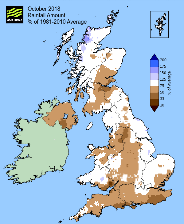
Rainfall totalled 129.6 mm for the month, with rain recorded on 15 days of which 9 were 'Wet days' (1.0mm +).
The Mean Temperature for the month was 8.70°c -- The Mean Max' was 12.85°c -- The Mean Min' 4.55°c.
We had 7 Air Frosts in the month (year 55) -- Grass frosts totalled 12 (year 92).
The 1 foot soil temp ranged from a low of 7.5°c on the 30th-31st to a high of 13.3°c on the 14th -- with a monthly mean of 11.1°c
The 1 meter soil temp ranged from a low of 10.8°c on the 31st to a high of 12.8°c on the 1st - 2nd -- with a monthly mean of 12.1°c
COMPARISONS:-
* October 2018 rainfall was 113.3% of the October average for 2008 - 2017
* October 2018 was 1.08°c colder than the October average for 2009 - 2017 and 0.4°c colder than the local long term average 1981-2010
* This makes the Jan' to Oct' period of 2018 0.05°c warmer than the average for 2009-17 and with 89.6% of average rainfall for 2008-17
JANUARY 2010
FEBRUARY 2010
MARCH 2010
APRIL 2010
MAY 2010
JUNE 2010
JULY 2010
AUGUST 2010
SEPTEMBER 2010
OCTOBER 2010
NOVEMBER 2010
DECEMBER 2010
JANUARY 2011
FEBRUARY 2011
MARCH 2011
APRIL 2011
MAY 2011
JUNE 2011
JULY 2011
AUGUST 2011
SEPTEMBER 2011
OCTOBER 2011
NOVEMBER 2011
DECEMBER 2011
JANUARY 2012
FEBRUARY 2012
MARCH 2012
APRIL 2012
MAY 2012
JUNE 2012
JULY 2012
AUGUST 2012
SEPTEMBER 2012
OCTOBER 2012
NOVEMBER 2012
DECEMBER 2012
SUMMER 2012
REVIEW OF 2012
JANUARY 2013
FEBRUARY 2013
MARCH 2013
APRIL 2013
MAY 2013
JUNE 2013
JULY 2013
AUGUST 2013
SEPTEMBER 2013
OCTOBER 2013
NOVEMBER 2013
DECEMBER 2013
REVIEW OF 2013
JANUARY 2014
FEBRUARY 2014
MARCH 2014
APRIL 2014
MAY 2014
JUNE 2014
JULY 2014
AUGUST 2014
SEPTEMBER 2014
OCTOBER 2014
NOVEMBER 2014
DECEMBER 2014
WINTER 2014
REVIEW OF 2014
JANUARY 2015
FEBRUARY 2015
MARCH 2015
APRIL 2015
MAY 2015
JUNE 2015
JULY 2015
AUGUST 2015
SEPTEMBER 2015
OCTOBER 2015
NOVEMBER 2015
DECEMBER 2015
REVIEW OF 2015
JANUARY 2016
FEBRUARY 2016
MARCH 2016
APRIL 2016
MAY 2016
JUNE 2016
JULY 2016
AUGUST 2016
SEPTEMBER 2016
OCTOBER 2016
NOVEMBER 2016
DECEMBER 2016
REVIEW OF 2016
JANUARY 2017
FEBRUARY 2017
MARCH 2017
APRIL 2017
MAY 2017
JUNE 2017
JULY 2017
AUGUST 2017
SEPTEMBER 2017
OCTOBER 2017
NOVEMBER 2017
DECEMBER 2017
REVIEW OF 2017
JANUARY 2018
FEBRUARY 2018
MARCH 2018
APRIL 2018
MAY 2018
JUNE 2018
JULY 2018
AUGUST 2018
SEPTEMBER 2018
OTHER ARTICLES
The Oldest Inhabitant
An Inch Of Scotch Mist
But it's meant to be Summer (Summer 2017)
© Darren Rogers 2010-18
Want to comment on this site? email